|
TOP SECRET - BIGOT - NEPTUNE
|
Copy N°1
17 May 1944
TOPOGRAPHICAL REPORT ON BRIDGES AT BENOUVILLE 098748 AND RANVILLE 104746
| 1. |
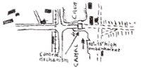
Sketch - BENOUVILLE 098748 |
| |
CANAL DE CAEN
|
| 2. |
Description of canal and immediate vicinity |
| |
- The current is slow. Depth reported to be 27' but can be regulated
by the locks at OUISTREHAM. Average width 150'. Banks average 6' in
height, and are of earth and broken stone.
- A track with waterbound macadam surface runs for most of the lenght
of the canal on both sides. On the WEST bank there is a lt rly (single
track). On each side of the br there are a few small houses. (For detail
see large scale model).
- The rd leading up to the br is on a 10' - 15' high embankment to keep
it above the flood level.
|
| 3. |
Description of the Br |
| |
- The water gap is 190' but from either bank there are abutments which
project 50' into the stream.
- The br is a steel girder, rolling lift br with masonry abutments.
Control mechanism is located in a cabin over rdway.
Overall length of br 190'
Lifting span 90'
Rd width 12', rdway asphalt or steel
- The br is reported as being mined. (Prepared for demolition).
|
| 4. |
Defs of Canal |
| |
- WEST bank : Open MG emplacements are visible on the canal banks on
each side of the br approach.
There are further open MG emplacements at 098748(2), 097748(2) and 096746.
- EAST side : SOUTH of rd close to the canal bank is a circular emplacement
approx 27' in diameter which is probable site for an atk gun but the
object in the emplacement cannot be identified as a gun. 25 yds SOUTH
of the above is an AA MG post on a tower 8' high.
- 60 yds NORTH of the rd close to the canal are 3 open MG emplacements,
12 yds apart, in a line facing NE. Approx 16 yds NE of these emplacements
is a concrete shelter or pillbox, measuring approx 17' X 14'.
- No wire defs are visible.
- Armed trawlers and R boats may be used in canal but it is considered
unlikely.
|
| 5. |
Description of R ORNE |
| |
- Average width 160' - 240'.
Tidal as far as CAEN.
Mean depth 9'.
Max tidal variation at Ouistreham 16'.
Max tidal variation at Caen 6' 5".
Banks 3' 6" high, of mud, and slope at approx 1 : 2
- There is a barrage at Caen which regulate the canal at the expense
of the river, hence speed and depth will vary considerably. Max current
will probably NOT exceed 3 knots.
- Ground between the river and canal is marshy and intersected by many
ditches and channels.
- A track 8' - 10' wide runs on both sides of the river for most of
its lenght.
|
| 6. |
Description of br 104746 and immediate vicinity |
| |
- The br is a two-span, cantilever latice girder, pivoted about a central
masonry pier. Turning mechanism is housed over pier between girders.
Overall length of br 350'
Spans, 2 at 100'
Load class 12
Rdway -9' tarmac (20' incl sidewalks).
It is thought that this br may no longer be used as a swing br.
Br has been reported as prepared for demolition.
- SOUTH of the rd and WEST of river is an orchard running NORTH and
SOUTH.
Each bank of the river is lined with poplars.
On the EAST of the river and SOUTH of the rd is a thick belt of trees
running parallel to the river, and about 50 yds away.
Both NORTH and SOUTH of the rd there are a few small houses, standing
in gardens or orchards. For details see large-scale model.
|
| 7. |
Defs on R ORNE |
| |
- EAST end and on the SOUTH side of the rd is a cam pill-box measuring
approx 16' X 16'. This may contain an atk weapon with main line of fire
EAST along rd.
There is a small AA MG emplacement adjoining this pill-box on the WEST
side.
- EAST side. Two open MG emplacements are visible on the NORTH side
of the rd.
- There is no wire visible.
- Two rd-blocks (probably tree trunks) lie alongside the rd at 105745
and 106744.
|
| |
Maj
BM 6 Airldg Bde
|
|
