|
|
42 USAAF Douglas C-47s did not return from the
missions of 6 and 7 June 1944. 1 – C-47A-15-DK
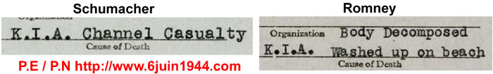
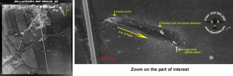
#42-92868 – Sainte Mere Eglise This well-know aerial photo, taken June 8, 1944, shows the trace of a crash on the right side of the N/S road, located south of Sainte Mere Eglise. Having, like others, researched information about this trace, we
have heard many times that it’s the aircraft flown by Lieutenant
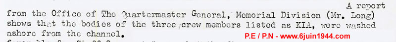
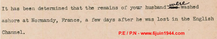
Roycraft and his 313th TCG crew. The Veterans Administration also wrote the following to the Navigator's
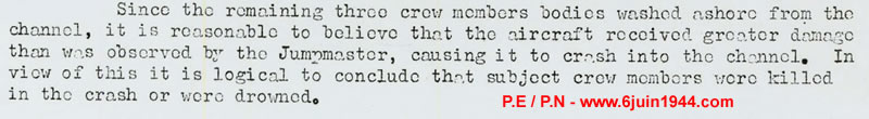
wife, Lieutenant Romney, in 1951. These official documents confirm that Lieutenant Roycraft's C-47 did not crash south of Sainte Mere Eglise, but into the Channel and that the crew's bodies were found on a beach few weeks later.
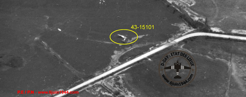
2 – C-47A-75-DL #42-100876 –
L'Isle Marie
Multiple books, websites, and monuments contend that Lieutenant
Marvin Muir's C-47 had crashed near Isle Marie, between Chef du Pont
and Pont l'Abbe.This most common photo is used to support the claim: 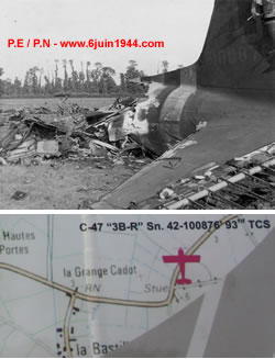
In fact, this photo doesn't tell us much except
the serial number of the C-47, which we’ll call ‘876.’
We are curious about the location and would like to have more evidence,
which may seem logical.
If we look at the information displayed on the map of the monument at Picauville (notwithstanding the wrong tail letter), Marvin Muir's aircraft crashed near l'Isle Marie.
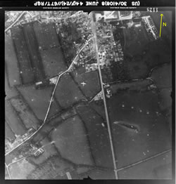
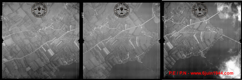
So, like the C-47 that crashed south of Ste Mere Eglise, we started looking for a track on the aerial photographs taken on June 6th or the following days.. Following photographs were taken on June 6th or on June 8th These photographs are of course zoomable, and others
are also available ... but there is no trace of a plane. Remember
that the initial photograph shows aircraft ‘876’ on
ground that is dry as far as the woodline in the distance,
and these pictures show that Isle Marie is completely surrounded
by water. There is no doubt for us - if Muir's aircraft was
in the immediate vicinity of Isle Marie, we would see it, especially
since in the initial photograph, there seems to be the signs of
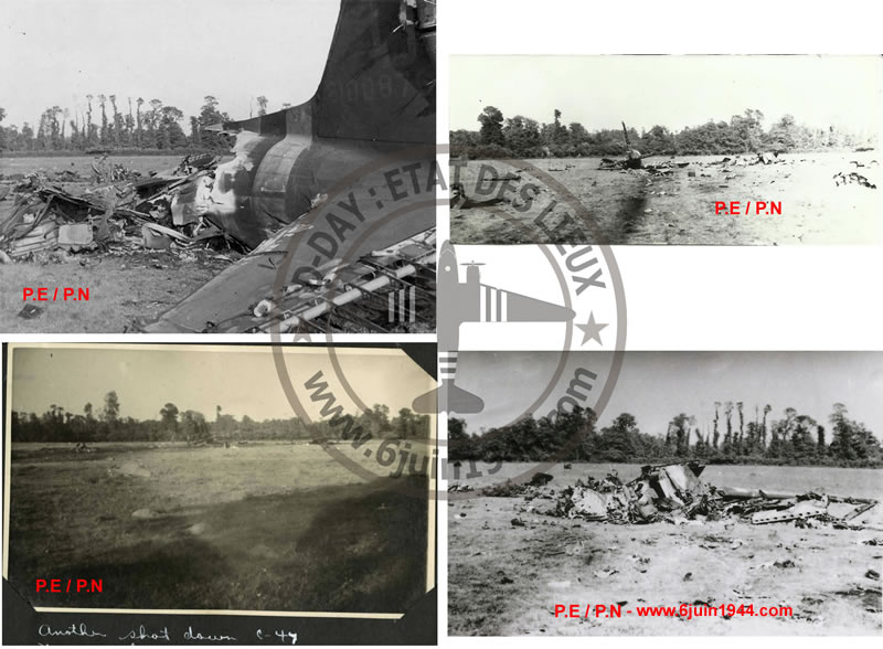
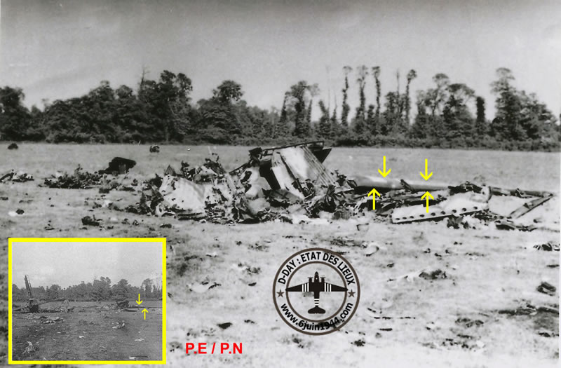
a major crash in a dry field that seems quite large. Then, we managed to get more photos taken on the ground which,
after a careful observation, also turned out to be Marvin Muir's
C-47. How did we determine that it was the same aircraft
on these different pictures? Very simple, just look at the shapes
of the trees to realize that we are in the same field as the picture
initially known. The black and white invasion stripes are clearly
visible and we can also determine that the leading edge is facing
the photographer. The de-icer shoe is also visible on the photo.
It should not be painted and the white stripe stopped just before
it. On the zoom we can see that the leading edge of
the wing, from its dihedral, is on the left . The wing is upside
down because, in the photo, we can discern the trace of the painted
star on the underside of the right wing only. Another element to
assert that it is the right wing: Years later HJR has found at this
place an intact C-47 wing tip with, at its end, the green navigation
light always present on right wings. We have also requested the IDPFs for the five aircrew members and for the paratrooper who stayed on board and was killed also during the crash. When we will receive them it will bring more information to add on this research. All these observations allow us to affirm that the C-47 crashed at the south entrance of Sainte Mere Eglise is C-47 #42-100876 belonging to the 93rd Troop Carrier Squadron - 439th Troop Carrier Group piloted by 2nd Lieutenant Marvin F. Muir and his crew. Also mis-information must no longer be
disseminated across the Internet or, worse, on the monument to lost
aircraft in Picauville.
To recap our findings, we believe clear and convincing photographic evidence proves that these two aircraft and their crews have been mis-located, and in order to honor the memory of the young airmen lost in the Liberation, the historical record must be corrected. If you have other photographs or documents about these two aircraft or their crews, feel free to contact us We are open to any discussion, remarks or additional elements that may be added to the file. © Patrick Elie - Philippe Nekrassoff - January 2018 Thanks to Brian Siddall, Bob Leicht and Neil Jones for their help. Photographs are from privates collections, aerial photographs are from National Collection of Aerial Photography. |
|||||||||||


| |